• About
  • Maps Examples
    • World
    • USA
    • Europe
      • France
      • Greece
      • Germany
      • Ireland
      • Italy
      • Netherlands
      • Norway
      • Poland
      • Russia
      • Spain
      • Sweden
      • United Kingdom
    • Asia
      • China
      • India
      • Indonesia
      • Pakistan
      • Thailand
    • America
      • Central America
      • South America
      • Argentina
      • Brazil
      • Canada
      • Mexico
    • Africa
      • South Africa
    • Australia
    • Eurasia
    • Middle East
      • Israel
      • Turkey
  • Advanced Customization
  • Contact
  • Buy Now
Skip to content
  • About
  • Maps Examples
    • World
    • USA
    • Europe
      • France
      • Greece
      • Germany
      • Ireland
      • Italy
      • Netherlands
      • Norway
      • Poland
      • Russia
      • Spain
      • Sweden
      • United Kingdom
    • Asia
      • China
      • India
      • Indonesia
      • Pakistan
      • Thailand
    • America
      • Central America
      • South America
      • Argentina
      • Brazil
      • Canada
      • Mexico
    • Africa
      • South Africa
    • Australia
    • Eurasia
    • Middle East
      • Israel
      • Turkey
  • Advanced Customization
  • Contact
  • Buy Now
Home / Pakistan / Interactive Map of Pakistan
Pakistan

Interactive Map of Pakistan

Interactive Map of Pakistan for WordPress with Zoom, created with Google Interactive Maps WordPress plugin.

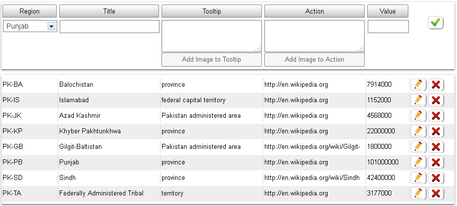
Interactive Map of Pakistan for WordPress (پاکستان کے انٹریکٹو نقشہ). This Google map of Pakistan based on Pakistan provinces population information, according to Wikipedia website.

Onhover of each province displays tooltip with Pakistan province name and type. Onclick of it – opens in a new window detailed Wikipedia article.

Google Geochart Zoom of Pakistan map is enabled.

Interactive Map of Pakistan Settings

This demo map is created with Google Interactive Maps WordPress plugin, which lets you create unlimited responsive interactive maps (Interactive World Maps, Europe Interactive Maps, Interactive US Maps, Africa Interactive Maps, Germany Interactive Maps, Interactive Maps of Canada and map of any other continent, country and US state).

Each map can be used multiple times in different posts and pages. Active data is shown in two ways: as fully colored Region, or Marker with colored bubble. Each active region can have: Tooltip on hover and an Action on click. Both tooltip and action values can have HTML text and images.

Plugin is based on Google GeoChart API, all necessary country and province data is included. Plugin enables to Zoom maps with mouse scroll and drag them. It creates SVG maps (No Flash).

Categories

  • Advanced Customization
  • Africa
  • America
  • Argentina
  • Asia
  • Australia
  • Brazil
  • Canada
  • Central America
  • China
  • Eurasia
  • Europe
  • France
  • Germany
  • Greece
  • India
  • Indonesia
  • Ireland
  • Israel
  • Italy
  • Mexico
  • Middle East
  • Netherlands
  • Norway
  • Pakistan
  • Poland
  • Russia
  • South Africa
  • South America
  • Spain
  • Sweden
  • Thailand
  • Turkey
  • United Kingdom
  • USA
  • World

Tags

background color (2) background image (2) content below (1) custom icons (1) custom logos (3) fixed zoom (5) hover color (3) iframe below (2) maps overlay (2) no neighbours (2) popup gallery (1) popup image (4) popup map (1) popup video (1) popup website (2) text labels (5) tooltip background color (1) tooltip border radius (1) tooltip image (2) tooltip text color (2) transparent background (2) transparent tooltip (1) US state (4)
Copyright © 2018. Created by Edarco. Powered by WordPress.